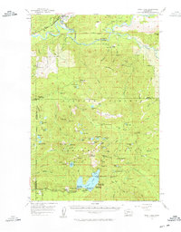
1957 Map of Spirit Lake
USGS Topo · Published 1963About this map
Spirit Lake and its surrounding peaks define this mid-century landscape within the Gifford Pinchot National Forest. This era shows the lake before modern transformations, bordered by established recreation sites like St Helens Lodge, Harmony Falls Lodge, and a Boy Scout Camp. To the north, the Cowlitz Chehalis & Cascade Railroad and a Private Logging Road follow the Cowlitz River, indicating the industrial logging activity that operated alongside the region's mining interests. Numerous prospect sites including the Sweden Mine, Polar Star Mine, and Chicago Mine are tucked into the drainages of Goat Mountain and Mt Margaret. The map records a complex network of fire lookouts and ranger stations, including the Strawberry Lookout and the Spirit Lake Ranger Station, which managed this vast timber and mineral resource.
Find a feature on this map
101 named features on this map. Tap any name to fly to it.
Don’t see what you’re looking for? This feature index may not catch every label — zoom into the map to look around manually.
Map Details
Editions of this 1957 Spirit Lake Map
3 editions found

Other maps of this area

1919 · Mount St Helens
USGS Topo · 1:125,000

1924 · Mt Rainier
USGS Topo · 1:96,000

1926 · Steamboat Mtn
USGS Topo · 1:125,000

1928 · Mt Rainier
USGS Topo · 1:125,000

1931 · Steamboat Mtn
USGS Topo · 1:125,000

1937 · Eatonville
USGS Topo · 1:125,000

1950 · Yakima
USGS Topo · 1:250,000

1953 · Hoquiam
USGS Topo · 1:250,000

1953 · Cougar
USGS Topo · 1:62,500

1953 · Elk Rock
USGS Topo · 1:62,500