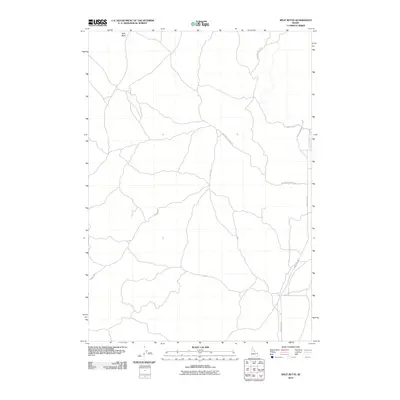
2010 Map of Split Butte
USGS Topo · Published 2010About this map
Split Butte rises above an open landscape in eastern Idaho, serving as the primary landmark for a region defined by a sparse network of unpaved access routes. This 2010 survey by the U.S. Geological Survey details the high desert plateau where transportation is dictated by the environment. Long, winding tracks such as Sand Creek Rd and Crooked Rd navigate the contours of the terrain, while Red Sand Creek Bed Rd follows the natural path of a drainage channel. The area remains largely undeveloped, preserving a character that reflects the vastness of the Upper Snake River Plain. The arrangement of these roads suggests a landscape primarily used for seasonal grazing or resource management, providing a clear record of the infrastructure supporting this corner of Fremont County.
Find a feature on this map
5 named features on this map. Tap any name to fly to it.
Don’t see what you’re looking for? This feature index may not catch every label — zoom into the map to look around manually.
Map Details
Editions of this 2010 Split Butte Map
This is the sole edition of this map. No revisions or reprints were ever made.
Other maps of this area

1955 · Ashton
USGS Topo · 1:250,000

1958 · Ashton
USGS Topo · 1:250,000

1960 · Ashton
USGS Topo · 1:250,000
1965 · Black Knoll
USGS Topo · 1:24,000

1965 · Lemon Lake
USGS Topo · 1:24,000
1965 · Split Butte
USGS Topo · 1:24,000

1965 · Blue Creek Reservoir
USGS Topo · 1:24,000

1965 · Crystal Butte
USGS Topo · 1:24,000
1965 · Bishop Mountain
USGS Topo · 1:24,000

1972 · Pine Butte
USGS Topo · 1:24,000