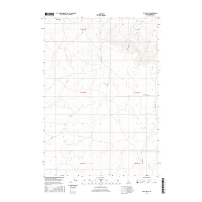
2017 Map of Split Butte
USGS Topo · Published 2017About this map
Split Butte dominates the northern skyline of this high-desert landscape in Fremont County, where volcanic geography meets the practical needs of rural water management. The terrain is defined by its drainage patterns and unpaved thoroughfares, most notably the seasonal catchment of the Sand Creek Reservoir along the eastern margin. Unlike the more lush regions of Idaho, this area shows a network of roads named for the environment they traverse, including Red Sand Creek Bed Rd and Snowshoe Beetle Rd. The grid of the Public Land Survey System, including t11n r40e and t10n r41e, provides a geometric structure to an otherwise fluid landscape of contours and dry creek beds. This 2017 survey reflects a modern view of the region's ranching or conservation layout, centered on the landmark butte and its surrounding basin.
Find a feature on this map
12 named features on this map. Tap any name to fly to it.
Don’t see what you’re looking for? This feature index may not catch every label — zoom into the map to look around manually.
Map Details
Editions of this 2017 Split Butte Map
This is the sole edition of this map. No revisions or reprints were ever made.
Other maps of this area

1955 · Ashton
USGS Topo · 1:250,000

1958 · Ashton
USGS Topo · 1:250,000

1960 · Ashton
USGS Topo · 1:250,000
1965 · Black Knoll
USGS Topo · 1:24,000

1965 · Lemon Lake
USGS Topo · 1:24,000
1965 · Split Butte
USGS Topo · 1:24,000

1965 · Blue Creek Reservoir
USGS Topo · 1:24,000

1965 · Crystal Butte
USGS Topo · 1:24,000
1965 · Bishop Mountain
USGS Topo · 1:24,000

1972 · Pine Butte
USGS Topo · 1:24,000