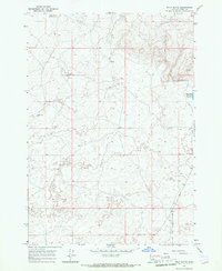
1965 Map of Split Butte
USGS Topo · Published 1967About this map
Split Butte dominates the northern elevation of this landscape in Fremont County, overlooking a high-desert terrain characterized by sparse water resources and specialized wildlife management. The eastern boundary is defined by the flow of Sand Creek, which supports the Sand Creek Reservoir Spillway and the nearby Sand Creek Wildlife Management Area Headquarters. This area represents a critical intersection of hydrology and land conservation in the mid-1960s, where infrastructure like several Water Tanks and scattered wells provided the necessary support for livestock or wildlife in an otherwise arid environment. A network of Jeep Trails and unimproved roads connects these remote points, reflecting the early development of recreational and administrative access into this corner of Idaho.
Find a feature on this map
10 named features on this map. Tap any name to fly to it.
Don’t see what you’re looking for? This feature index may not catch every label — zoom into the map to look around manually.
Map Details
Editions of this 1965 Split Butte Map
This is the sole edition of this map. No revisions or reprints were ever made.
Other maps of this area

1955 · Ashton
USGS Topo · 1:250,000

1958 · Ashton
USGS Topo · 1:250,000

1960 · Ashton
USGS Topo · 1:250,000
1965 · Black Knoll
USGS Topo · 1:24,000

1965 · Lemon Lake
USGS Topo · 1:24,000

1965 · Blue Creek Reservoir
USGS Topo · 1:24,000

1965 · Crystal Butte
USGS Topo · 1:24,000
1965 · Bishop Mountain
USGS Topo · 1:24,000

1972 · Pine Butte
USGS Topo · 1:24,000
1972 · Split Rock
USGS Topo · 1:24,000