
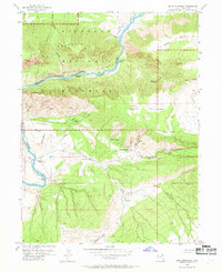
1955 Map of Split Mountain
USGS Topo · Published 1957About this map
Dinosaur National Monument dominates this mid-1950s survey, defined by the powerful carving force of the Green River as it cuts through Split Mountain. This section of the river is a high-energy corridor of whitewater, featuring named hazards such as Moonshine Rapids, SOB Rapids, Schoolboy Rapids, and Inglesby Rapids. The landscape transitions from the sheer canyon walls and high elevations of the Yampa Plateau to the valley floor along Cub Creek.
Find a feature on this map
37 named features on this map. Tap any name to fly to it.
Don’t see what you’re looking for? This feature index may not catch every label — zoom into the map to look around manually.
Map Details
Editions of this 1955 Split Mountain Map
2 editions found
Other maps of this area

1885 · Ashley
USGS Topo · 1:250,000

1907 · Jensen
USGS Topo · 1:125,000

1910 · Jensen
USGS Topo · 1:125,000

1954 · Vernal
USGS Topo · 1:250,000

1955 · Island Park
USGS Topo · 1:24,000

1955 · Stuntz Reservoir
USGS Topo · 1:24,000

1955 · Jones Hole
USGS Topo · 1:24,000

1958 · Vernal
USGS Topo · 1:250,000

1960 · Vernal
USGS Topo · 1:250,000
1965 · Dinosaur Quarry
USGS Topo · 1:24,000