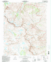
1994 Map of Split Mtn
USGS Topo · Published 1997About this map
Split Mountain and the high Sierra crest form the backbone of this 1990s wilderness survey, where the boundary between Inyo National Forest and Kings Canyon National Park follows the jagged ridgeline. The landscape is defined by its glacial activity, featuring the Middle Palisade Glacier and the Split Mountain Glaciers, which feed high-altitude basins like the Upper Basin and Big Pine Lakes. For researchers, the map provides precise locations for industrial activities at the northern edge, including the Blue Star Mines and an Open Pit Mine. Notable peaks such as Norman Clyde Pk and Temple Crag dominate the terrain, while travelers are shown utilizing high-altitude crossings like Mather Pass and Southfork Pass to navigate the steep divides of the John Muir Wilderness.
Find a feature on this map
52 named features on this map. Tap any name to fly to it.
Don’t see what you’re looking for? This feature index may not catch every label — zoom into the map to look around manually.
Map Details
Editions of this 1994 Split Mtn Map
This is the sole edition of this map. No revisions or reprints were ever made.
Other maps of this area

1903 · Tehipite
USGS Topo · 1:125,000

1905 · Tehipite
USGS Topo · 1:125,000

1907 · Mt. Whitney
USGS Topo · 1:125,000

1912 · Mt. Goddard
USGS Topo · 1:125,000

1913 · Bishop
USGS Topo · 1:125,000

1919 · Mt. Whitney
USGS Topo · 1:125,000

1937 · Mt. Whitney
USGS Topo · 1:125,000

1947 · Mariposa
USGS Topo · 1:250,000

1948 · Fresno
USGS Topo · 1:250,000

1948 · Mariposa
USGS Topo · 1:250,000