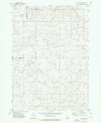
1972 Map of Split Rock
USGS Topo · Published 1976About this map
Split Rock and the volcanic depressions of Butte Crater define this high-altitude landscape along the border of Clark and Fremont counties. Surveyed in the early 1970s, the terrain is characterized by its geological features, including several named caves and an Ice Cave located in the northern reaches. The area is intersected by a network of primitive transportation routes, most notably the Red Road and Crooked Road, which suggest a remote region utilized for seasonal access rather than permanent settlement. The presence of a Drill Hole and scattered wells indicates exploration and resource management within this volcanic field. This sheet provides a detailed view of the natural topography before more modern developments, preserving the original paths of the Jeep Trail and connections toward Sand Creek Road.
Find a feature on this map
12 named features on this map. Tap any name to fly to it.
Don’t see what you’re looking for? This feature index may not catch every label — zoom into the map to look around manually.
Map Details
Editions of this 1972 Split Rock Map
This is the sole edition of this map. No revisions or reprints were ever made.
Other maps of this area

1955 · Ashton
USGS Topo · 1:250,000

1958 · Ashton
USGS Topo · 1:250,000

1960 · Ashton
USGS Topo · 1:250,000
1965 · Black Knoll
USGS Topo · 1:24,000
1965 · Split Butte
USGS Topo · 1:24,000

1965 · Crystal Butte
USGS Topo · 1:24,000

1972 · Pine Butte
USGS Topo · 1:24,000
1972 · Snowshoe Butte
USGS Topo · 1:24,000
1972 · Big Grassy Ridge SE
USGS Topo · 1:24,000
1972 · Idmon
USGS Topo · 1:24,000