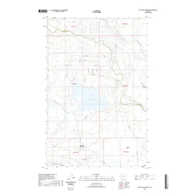
2020 Map of Split Rock Junction
USGS Topo · Published 2020About this map
The Sun River winds through the eastern portion of this Montana landscape, shaping a terrain defined by complex water management and high-plains topography. Centered on the Willow Creek Reservoir, the map illustrates a network of essential irrigation infrastructure, including the Sun River Slope Canal, Floweree Canal, and Kirkaldie Canal. These waterworks supported the agricultural vitality of the region near Split Rock Junction, where the local road system branches out to service scattered ranchlands. To the south, the terrain rises toward distinct landmarks such as Carey Butte and Sandy Butte, while the lowlands features the Kirkaldie Flats and the drainage of Willow Creek. This area, situated along the border of Lewis and Clark County and Teton County, reflects the modern engineering required to sustain ranching and farming in the shadow of the Rocky Mountain Front.
Find a feature on this map
32 named features on this map. Tap any name to fly to it.
Don’t see what you’re looking for? This feature index may not catch every label — zoom into the map to look around manually.
Map Details
Editions of this 2020 Split Rock Junction Map
This is the sole edition of this map. No revisions or reprints were ever made.
Other maps of this area

1903 · Saypo
USGS Topo · 1:125,000

1903 · Coopers Lake
USGS Topo · 1:125,000

1920 · Choteau
USGS Topo · 1:125,000

1943 · Hogan
USGS Topo · 1:125,000

1955 · Choteau
USGS Topo · 1:250,000

1957 · Choteau
USGS Topo · 1:250,000

1958 · Choteau
USGS Topo · 1:250,000

1958 · Barr Creek
USGS Topo · 1:24,000
1958 · Split Rock Lake
USGS Topo · 1:24,000

1960 · Gilman
USGS Topo · 1:62,500