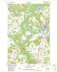
1982 Map of Spooner
USGS Topo · Published 1983About this map
The Yellow River winds through the heart of this Washburn County landscape, anchoring a region defined by its glacial lakes and wetland industries. In the early 1980s, the city of Spooner serves as a vital hub where the Chicago and North Western railroad lines converge at Chicago Junction. The map captures a diverse land use pattern, from the University of Wisconsin Experimental Farm on the eastern edge of town to the specialized Cranberry Bogs and Cranberry Lake to the northwest.
Find a feature on this map
52 named features on this map. Tap any name to fly to it.
Don’t see what you’re looking for? This feature index may not catch every label — zoom into the map to look around manually.
Map Details
Editions of this 1982 Spooner Map
This is the sole edition of this map. No revisions or reprints were ever made.
Other maps of this area

1948 · Spooner
USGS Topo · 1:48,000

1949 · Hertel
USGS Topo · 1:48,000

1949 · Spooner
USGS Topo · 1:48,000

1951 · Cumberland
USGS Topo · 1:48,000

1951 · Shell Lake
USGS Topo · 1:48,000

1953 · Rice Lake
USGS Topo · 1:250,000

1953 · Stillwater
USGS Topo · 1:250,000

1955 · Hertel
USGS Topo · 1:62,500

1955 · Stillwater
USGS Topo · 1:250,000

1956 · Cumberland
USGS Topo · 1:62,500