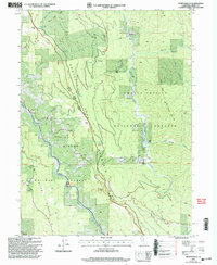
1998 Map of Sportshaven
USGS Topo · Published 2003About this map
South Fork Mountain and the South Fork Trinity River dominate this terrain in the Trinity National Forest region. This 1990s revision reveals a landscape of deep canyons and ridgelines, where family-named holdings like McClellan Place and Graham Place sit alongside the Mad River. The presence of the Klondike Mine in the southeast suggests the area's prospecting history, while the Mad River Campground and the namesake Sportshaven settlement point to its more contemporary use for recreation and timber management. The map's detail is particularly useful for tracing early property lines relative to the Humboldt Base Line, which bisects the quadrangle. From the distinctively named Lemonade Spring to the high point of Bear Wallow Mtn, the sheet provides a precise record of the complex topography within the Shasta-Trinity National Forests and Six Rivers National Forest.
Find a feature on this map
45 named features on this map. Tap any name to fly to it.
Don’t see what you’re looking for? This feature index may not catch every label — zoom into the map to look around manually.
Map Details
Editions of this 1998 Sportshaven Map
This is the sole edition of this map. No revisions or reprints were ever made.
Other maps of this area

1909 · Big Bar
USGS Topo · 1:96,000

1914 · Pilot Creek
USGS Topo · 1:62,500

1915 · Big Bar and Vicinity
USGS Topo · 1:250,000

1918 · Anada
USGS Topo · 1:62,500

1931 · Hoaglin
USGS Topo · 1:96,000

1935 · Hoaglin
USGS Topo · 1:125,000

1949 · Blocksburg
USGS Topo · 1:62,500

1951 · Blocksburg
USGS Topo · 1:62,500

1951 · Pilot Creek
USGS Topo · 1:62,500

1951 · Hyampom
USGS Topo · 1:62,500