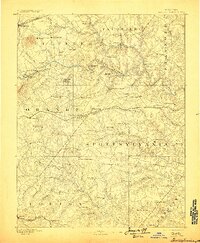
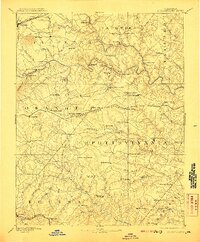
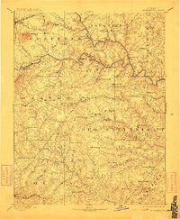
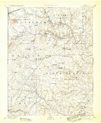
1892 Map of Spottsylvania
USGS Topo · Published 1898About this map
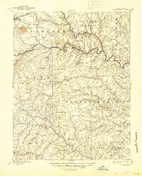
The Rappahannock River carves a winding path through this Piedmont landscape, serving as a historic boundary for the Virginia counties of Culpeper, Fauquier, and Spottsylvania. Surveyed in the late 1880s, the terrain reveals a network of small crossroad settlements and traditional waystations such as Wilderness Tavern, Todds Tavern, and Wallers Tavern. Industrial activity is evident in the presence of the Vaucluse Gold Mine and the White Hall Gold Mine, highlighting the region's mineral history. Transportation is defined by river crossings like Raccoon Ford and the Germanna Bridge, alongside the path of the Narrow Gauge Railroad. For genealogists, the map is a detailed record of late 19th-century community hubs, from Chancellorsville and Locust Grove to numerous rural sanctuaries like Shady Grove Church and New Hope Church.
Find a feature on this map
88 named features on this map. Tap any name to fly to it.
Don’t see what you’re looking for? This feature index may not catch every label — zoom into the map to look around manually.
Map Details
Editions of this 1892 Spottsylvania Map
6 editions found
Other maps of this area

1887 · Spottsylvania
USGS Topo · 1:125,000

1889 · Fredericksburg
USGS Topo · 1:125,000

1890 · Goochland
USGS Topo · 1:125,000

1890 · Mt. Vernon
USGS Topo · 1:125,000

1891 · Palmyra
USGS Topo · 1:125,000

1891 · Mt. Vernon
USGS Topo · 1:125,000

1892 · Fredericksburg
USGS Topo · 1:125,000

1892 · Spottsylvania
USGS Topo · 1:125,000

1892 · Goochland
USGS Topo · 1:125,000

1892 · Gordonsville
USGS Topo · 1:125,000