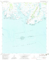
1954 Map of Sprague Island
USGS Topo · Published 1980About this map
St Marks National Wildlife Refuge dominates this coastal landscape, where the St Marks River empties into Apalachee Bay. The 1954 topography reveals a complex network of tidal bayous and marshlands, including West Bayou, Africa Bayou, and Shine Cr. Human infrastructure is concentrated near the coast, notably the Lighthouse and the Coast Guard Station BM 7.
Find a feature on this map
59 named features on this map. Tap any name to fly to it.
Don’t see what you’re looking for? This feature index may not catch every label — zoom into the map to look around manually.
Map Details
Editions of this 1954 Sprague Island Map
4 editions found
Other maps of this area

1940 · Arran
USGS Topo · 1:62,500

1943 · Arran
USGS Topo · 1:62,500

1943 · Lighthouse Point
USGS Topo · 1:24,000

1945 · Lighthouse Point
USGS Topo · 1:31,680

1949 · Apalachicola
USGS Topo · 1:250,000

1954 · Sprague Island
USGS Topo · 1:24,000

1954 · St. Marks NE
USGS Topo · 1:24,000

1954 · St. Marks
USGS Topo · 1:24,000

1954 · Cobb Rocks
USGS Topo · 1:24,000

1954 · Tallahassee
USGS Topo · 1:250,000