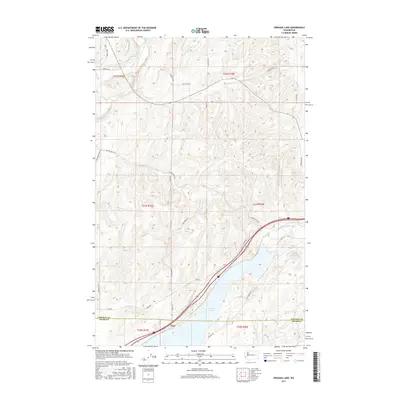
2017 Map of Sprague Lake
USGS Topo · Published 2017About this map
Sprague Lake dominates the southern landscape of this 2017 survey, sitting at the junction of Lincoln and Adams counties. The area is characterized by the complex hydrology of the Channeled Scablands, where water bodies like Clear Lake and Eastman Pond are fed by a network of seasonal and perennial streams including Crab Cr and Negro Creek. The settlement of Pifer sits near the southwestern shore of the lake, serving as a focal point in a region otherwise defined by large-scale agricultural divisions and a grid of rural roads. Transport routes such as Lake Rd and Bob Lee Rd follow the natural contours of the terrain, weaving between the basalt coulees and drainage basins typical of this part of Eastern Washington. The map provides a clear record of the intersection between established land-management boundaries and the erratic natural features of the scabland interior.
Find a feature on this map
34 named features on this map. Tap any name to fly to it.
Don’t see what you’re looking for? This feature index may not catch every label — zoom into the map to look around manually.
Map Details
Editions of this 2017 Sprague Lake Map
This is the sole edition of this map. No revisions or reprints were ever made.
Other maps of this area

1953 · Ritzville
USGS Topo · 1:250,000

1954 · Sprague
USGS Topo · 1:62,500

1955 · Spokane
USGS Topo · 1:250,000

1958 · Spokane
USGS Topo · 1:250,000

1959 · Ritzville
USGS Topo · 1:250,000

1964 · Lamont NW
USGS Topo · 1:24,000

1964 · Karakul Hills
USGS Topo · 1:24,000

1964 · Palm Lake
USGS Topo · 1:24,000

1965 · Ritzville
USGS Topo · 1:250,000

1969 · Sprague Lake
USGS Topo · 1:24,000