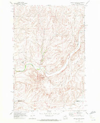
1969 Map of Sprague Lake SW
USGS Topo · Published 1972About this map
Crab Creek winds through the basalt-heavy terrain of the Channeled Scablands at the boundary of Lincoln and Adams Counties. This 1969 field-checked survey reveals a landscape shaped by both natural drainage and industrial infrastructure, with a significant Pipeline and high-voltage Substation cutting through the coulees. Resource extraction is evident in the scattered Gravel Pits and Borrow Pits that flank the primary watercourse. Navigation across this sparsely populated region relies on a network of rugged paths, including an extensive Jeep Trail system and the established Wellsandt Road. The map provides a detailed view of the era's land use, where natural Spring features and man-made infrastructure coexist in the high plateau country.
Find a feature on this map
10 named features on this map. Tap any name to fly to it.
Don’t see what you’re looking for? This feature index may not catch every label — zoom into the map to look around manually.
Map Details
Editions of this 1969 Sprague Lake SW Map
This is the sole edition of this map. No revisions or reprints were ever made.
Other maps of this area

1953 · Ritzville
USGS Topo · 1:250,000

1959 · Ritzville
USGS Topo · 1:250,000

1964 · Karakul Hills
USGS Topo · 1:24,000

1964 · Palm Lake
USGS Topo · 1:24,000

1965 · Ritzville
USGS Topo · 1:250,000

1967 · Ritzville NE
USGS Topo · 1:24,000

1969 · Harrington
USGS Topo · 1:24,000

1969 · Sprague Lake
USGS Topo · 1:24,000

1969 · Lords Valley
USGS Topo · 1:24,000
1969 · Sprague Lake NE
USGS Topo · 1:24,000