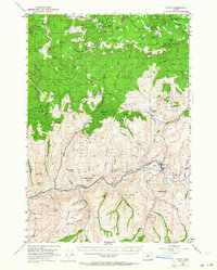
1953 Map of Spray
USGS Topo · Published 1960About this map
The John Day River carves through the central Oregon landscape, anchoring the riverside town of Spray and its adjacent landing field. This mid-century survey reveals a complex network of canyons and high-desert terrain, where family-named locations like Corncob Ranch and small settlements like Winlock and Wetmore denote the human footprint in Wheeler County. To the north, the high timber of the Umatilla National Forest covers significant elevations, including Wheeler Pt and Collins Butte.
Find a feature on this map
65 named features on this map. Tap any name to fly to it.
Don’t see what you’re looking for? This feature index may not catch every label — zoom into the map to look around manually.
Map Details
Editions of this 1953 Spray Map
2 editions found
Other maps of this area

1916 · Condon
USGS Topo · 1:125,000

1926 · Mitchell
USGS Topo · 1:125,000

1953 · Richmond
USGS Topo · 1:62,500

1953 · Kimberly
USGS Topo · 1:62,500

1953 · Picture
USGS Topo · 1:62,500

1953 · Spray
USGS Topo · 1:62,500

1953 · Pendleton
USGS Topo · 1:250,000

1953 · The Dalles
USGS Topo · 1:250,000

1955 · Bend
USGS Topo · 1:250,000

1955 · Canyon City
USGS Topo · 1:250,000