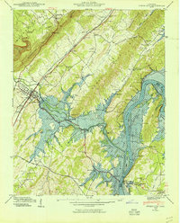
1940 Map of Spring City
USGS Topo · Published 1954About this map
The Cumberland Escarpment looms over the valley floor where the Southern railroad connects the communities of Spring City and Lorraine. This 1940 field examination by the Tennessee Valley Authority documents a landscape in flux, specifically highlighting blue-stippled areas designated for submersion by the Watts Bar Reservoir. This transformation of the Tennessee River corridor impacts established settlements like Rhea Springs, where the Rhea Springs Cem and local schoolhouses sit near the rising waters.
Find a feature on this map
60 named features on this map. Tap any name to fly to it.
Don’t see what you’re looking for? This feature index may not catch every label — zoom into the map to look around manually.
Map Details
Editions of this 1940 Spring City Map
2 editions found
Other maps of this area

1887 · Kingston
USGS Topo · 1:125,000

1891 · Kingston
USGS Topo · 1:125,000

1893 · Kingston
USGS Topo · 1:125,000

1935 · Rockwood
USGS Topo · 1:24,000

1935 · Evensville
USGS Topo · 1:24,000

1935 · Decatur
USGS Topo · 1:24,000

1935 · Pennine
USGS Topo · 1:24,000

1936 · Roddy
USGS Topo · 1:24,000

1936 · Spring City
USGS Topo · 1:24,000
1936 · Grassy Cove
USGS Topo · 1:24,000