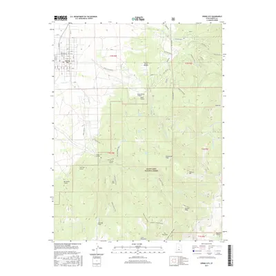
2017 Map of Spring City
USGS Topo · Published 2017About this map
Spring City occupies the northwestern corner of this landscape, its grid of streets such as N Main St and E Center sitting at the base of the rising Wasatch Plateau. The town's early history is anchored by the Spring City Pioneer Cem, while the surrounding geography is defined by a series of steep canyons and ridges. To the east and south, the terrain climbs sharply into the Manti-LaSal National Forest, where features like Bill Allred Canyon, Grizzly Gulch, and Maple Canyon carve into the high ground.
Find a feature on this map
75 named features on this map. Tap any name to fly to it.
Don’t see what you’re looking for? This feature index may not catch every label — zoom into the map to look around manually.
Map Details
Editions of this 2017 Spring City Map
This is the sole edition of this map. No revisions or reprints were ever made.
Other maps of this area

1885 · Manti
USGS Topo · 1:250,000

1895 · Manti
USGS Topo · 1:250,000

1951 · Moroni
USGS Topo · 1:62,500

1956 · Price
USGS Topo · 1:250,000

1960 · Price
USGS Topo · 1:250,000

1962 · Price
USGS Topo · 1:250,000

1965 · Huntington Reservoir
USGS Topo · 1:24,000

1966 · Spring City
USGS Topo · 1:24,000

1966 · Chester
USGS Topo · 1:24,000
1966 · Ephraim
USGS Topo · 1:24,000