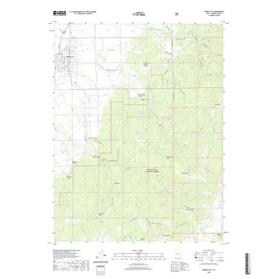
2020 Map of Spring City
USGS Topo · Published 2020About this map
Spring City serves as the primary hub of this area, positioned in the northwest corner within the Sanpete Valley. The town's grid of streets, including N Main St and E Center, transition abruptly into the dramatic eastern elevations of the Manti-La Sal National Forest. This abrupt shift from agricultural valley floor to the high terrain of the Wasatch Plateau is defined by a series of deep canyons and ridges, such as Canal Canyon and Bill Allred Canyon. Local history and geography are preserved in labels like Pioneer Cem and named high-country clearings like Freeman Allred Meadow. The irrigation and water management essential for valley life are evident through features like Point Ditch and several named springs, including Dry Lake Spring and Black Willow Spring, which fed the developing settlements below the high peaks of Knob Mountain and Haystack Mtn.
Find a feature on this map
79 named features on this map. Tap any name to fly to it.
Don’t see what you’re looking for? This feature index may not catch every label — zoom into the map to look around manually.
Map Details
Editions of this 2020 Spring City Map
This is the sole edition of this map. No revisions or reprints were ever made.
Other maps of this area

1885 · Manti
USGS Topo · 1:250,000

1895 · Manti
USGS Topo · 1:250,000

1951 · Moroni
USGS Topo · 1:62,500

1956 · Price
USGS Topo · 1:250,000

1960 · Price
USGS Topo · 1:250,000

1962 · Price
USGS Topo · 1:250,000

1965 · Huntington Reservoir
USGS Topo · 1:24,000

1966 · Spring City
USGS Topo · 1:24,000

1966 · Chester
USGS Topo · 1:24,000
1966 · Ephraim
USGS Topo · 1:24,000