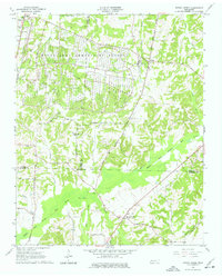
1966 Map of Spring Creek
USGS Topo · Published 1977About this map
The vast installation of the Milan Army Ammunition Plant dominates the northern landscape of this region where Gibson, Carroll, and Madison counties meet. The massive facility, shown with its extensive grid of bunkers and industrial infrastructure, represents the significant military-industrial footprint in West Tennessee during the mid-20th century. Outside the facility gates, the terrain transitions to the winding bottomlands of the Middle Fork Forked Deer River and its numerous tributaries like Wolf Creek and Crooked Creek.
Find a feature on this map
45 named features on this map. Tap any name to fly to it.
Don’t see what you’re looking for? This feature index may not catch every label — zoom into the map to look around manually.
Map Details
Editions of this 1966 Spring Creek Map
3 editions found
Other maps of this area

1950 · Jackson North
USGS Topo · 1:24,000

1951 · Jackson North
USGS Topo · 1:24,000

1952 · Milan
USGS Topo · 1:24,000

1953 · Claybrook
USGS Topo · 1:24,000

1955 · Juno
USGS Topo · 1:24,000

1956 · Blytheville
USGS Topo · 1:250,000

1959 · Medina
USGS Topo · 1:24,000

1959 · Blytheville
USGS Topo · 1:250,000

1966 · Spring Creek
USGS Topo · 1:24,000

1966 · Mc Lemoresville
USGS Topo · 1:24,000