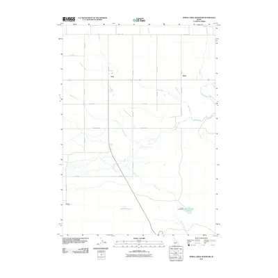
2010 Map of Spring Creek Reservoir
USGS Topo · Published 2010About this map
Camas Creek and its many tributaries, including Minear Creek and Knowlton Creek, define the drainage patterns of this Idaho landscape. The map centers on agricultural and water management infrastructure, most notably the Spring Creek Reservoir and its associated Spring Creek Dam in the southeast. Smaller settlements like Selby and Rands are situated along the primary east-west corridor, while family-named landmarks like the Neilsen Reservoir and Bahr Ranch Rd point to the local ranching history of the area. For genealogists, the Manard Cemetery sits near the southwestern corner along Fir Grove Rd, providing a vital point of reference for local families. The grid of rural roads, such as Base Line Rd and Frostenson Rd, illustrates the systematic division of land in this part of Camas County.
Find a feature on this map
28 named features on this map. Tap any name to fly to it.
Don’t see what you’re looking for? This feature index may not catch every label — zoom into the map to look around manually.
Map Details
Editions of this 2010 Spring Creek Reservoir Map
This is the sole edition of this map. No revisions or reprints were ever made.
Other maps of this area

1955 · Hailey
USGS Topo · 1:250,000

1957 · Fairfield
USGS Topo · 1:62,500

1957 · Thorn Creek
USGS Topo · 1:62,500

1957 · Davis Mountain
USGS Topo · 1:62,500

1957 · Blaine
USGS Topo · 1:62,500

1959 · Hailey
USGS Topo · 1:250,000

1962 · Hailey
USGS Topo · 1:250,000
1986 · Phillips
USGS Topo · 1:24,000
1986 · Thorn Creek Reservoir
USGS Topo · 1:24,000
1986 · Fir Grove Mountain
USGS Topo · 1:24,000