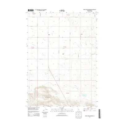
2013 Map of Spring Creek Reservoir
USGS Topo · Published 2013About this map
The Camas Prairie of southern Idaho unfolds across this map, showcasing a high-altitude agricultural and ranching landscape at the base of the Mount Bennett Hills. This era of water management is clearly defined by structures such as the Spring Cr Reservoir and Neilsen Reservoir, which capture runoff from the southern highlands. Small-scale rural centers like Selby and Rands are joined by a network of secondary roads and section lines, including Old Highway 46. Genealogists may find interest in the isolated Manard Cem located in the southwestern corner near Fir Grove Rd. The terrain is characterized by a complex drainage system where numerous seasonal and perennial streams, including Camas Cr, Minear Cr, and Knowlton Cr, flow from the foothills onto the flatter prairie floor.
Find a feature on this map
38 named features on this map. Tap any name to fly to it.
Don’t see what you’re looking for? This feature index may not catch every label — zoom into the map to look around manually.
Map Details
Editions of this 2013 Spring Creek Reservoir Map
This is the sole edition of this map. No revisions or reprints were ever made.
Other maps of this area

1955 · Hailey
USGS Topo · 1:250,000

1957 · Fairfield
USGS Topo · 1:62,500

1957 · Thorn Creek
USGS Topo · 1:62,500

1957 · Davis Mountain
USGS Topo · 1:62,500

1957 · Blaine
USGS Topo · 1:62,500

1959 · Hailey
USGS Topo · 1:250,000

1962 · Hailey
USGS Topo · 1:250,000
1986 · Phillips
USGS Topo · 1:24,000
1986 · Thorn Creek Reservoir
USGS Topo · 1:24,000
1986 · Fir Grove Mountain
USGS Topo · 1:24,000