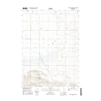
2017 Map of Spring Creek Reservoir
USGS Topo · Published 2017About this map
Camas Prairie defines the central landscape of this Idaho quadrangle, where high-desert agriculture meets the rising topography of the Mount Bennett Hills to the south. The irrigation needs of this arid region are evident in the management of local waterways, including Spring Cr Reservoir and Neilsen Reservoir, which capture runoff from seasonal drainages like Daugherty Cr and Minear Cr.
Find a feature on this map
34 named features on this map. Tap any name to fly to it.
Don’t see what you’re looking for? This feature index may not catch every label — zoom into the map to look around manually.
Map Details
Editions of this 2017 Spring Creek Reservoir Map
This is the sole edition of this map. No revisions or reprints were ever made.
Other maps of this area

1955 · Hailey
USGS Topo · 1:250,000

1957 · Fairfield
USGS Topo · 1:62,500

1957 · Thorn Creek
USGS Topo · 1:62,500

1957 · Davis Mountain
USGS Topo · 1:62,500

1957 · Blaine
USGS Topo · 1:62,500

1959 · Hailey
USGS Topo · 1:250,000

1962 · Hailey
USGS Topo · 1:250,000
1986 · Phillips
USGS Topo · 1:24,000
1986 · Thorn Creek Reservoir
USGS Topo · 1:24,000
1986 · Fir Grove Mountain
USGS Topo · 1:24,000