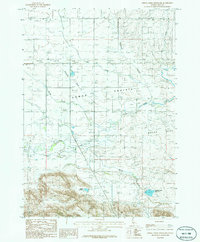
1986 Map of Spring Creek Reservoir
USGS Topo · Published 1986About this map
Camas Prairie and Macon Flat dominate this mid-1980s landscape, reflecting a region defined by its wide basins and crucial water management. The survey documents a network of small settlements and transportation corridors, including the rail siding at Rands and the community of Selby. A notable shift in the local infrastructure is evidenced by the Abandoned Railroad that cuts across the prairie, marking the transition away from earlier rail-dependent shipping for the area's agricultural products.
Find a feature on this map
15 named features on this map. Tap any name to fly to it.
Don’t see what you’re looking for? This feature index may not catch every label — zoom into the map to look around manually.
Map Details
Editions of this 1986 Spring Creek Reservoir Map
This is the sole edition of this map. No revisions or reprints were ever made.
Other maps of this area

1955 · Hailey
USGS Topo · 1:250,000

1957 · Fairfield
USGS Topo · 1:62,500

1957 · Thorn Creek
USGS Topo · 1:62,500

1957 · Davis Mountain
USGS Topo · 1:62,500

1957 · Blaine
USGS Topo · 1:62,500

1959 · Hailey
USGS Topo · 1:250,000

1962 · Hailey
USGS Topo · 1:250,000
1986 · Phillips
USGS Topo · 1:24,000
1986 · Thorn Creek Reservoir
USGS Topo · 1:24,000
1986 · Fir Grove Mountain
USGS Topo · 1:24,000