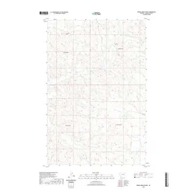
2020 Map of Spring Creek School
USGS Topo · Published 2020About this map
Spring Creek School stands as a focal point in this sparsely settled region of Garfield County, where the landscape is defined by an intricate network of intermittent drainage systems. The terrain is deeply etched by watercourses including Spring Creek, Wolf Creek, and Nancy Russell Creek, alongside the Dry Fork Nancy Russell Creek. These waterways dictate the local geography, creating a complex series of ridges and draws characteristic of the Montana plains. Sparse road infrastructure, such as Burma Rd and Boxcar Rd, provides the primary access through the townships of T20N and T19N. The presence of a named schoolhouse in such an open environment suggests its historical importance as a community center for ranching families distributed across the surrounding rangeland.
Find a feature on this map
13 named features on this map. Tap any name to fly to it.
Don’t see what you’re looking for? This feature index may not catch every label — zoom into the map to look around manually.
Map Details
Editions of this 2020 Spring Creek School Map
This is the sole edition of this map. No revisions or reprints were ever made.
Other maps of this area

1954 · Jordan
USGS Topo · 1:250,000

1956 · Jordan
USGS Topo · 1:250,000

1958 · Jordan
USGS Topo · 1:250,000

1964 · Jordan
USGS Topo · 1:250,000

1965 · Spring Creek School
USGS Topo · 1:24,000

1965 · Lost Creek
USGS Topo · 1:24,000

1965 · Cap Rock Butte
USGS Topo · 1:24,000

1965 · Pine Grove School
USGS Topo · 1:24,000
1967 · Hay Coulee
USGS Topo · 1:24,000
1967 · Benzien
USGS Topo · 1:24,000