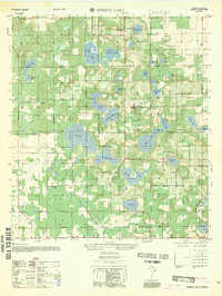
1954 Map of Spring Lake
USGS Topo · Published 1981About this map
Hickory Hill rises as a prominent landmark in this mid-century survey of the lake-strewn landscape along the border of Hernando and Pasco Counties. The area is defined by an intricate network of small water bodies, ranging from the central expanse of Hancock Lake and Middle Lake to smaller named ponds like Zuke Pond and Patsy Pond. These waters shaped the development of early settlements such as Spring Lake and Jessamine, where the local economy and social life were anchored by rural institutions.
Find a feature on this map
39 named features on this map. Tap any name to fly to it.
Don’t see what you’re looking for? This feature index may not catch every label — zoom into the map to look around manually.
Map Details
Editions of this 1954 Spring Lake Map
5 editions found
Other maps of this area

1954 · Spring Lake
USGS Topo · 1:24,000

1954 · Ehren
USGS Topo · 1:24,000

1954 · San Antonio
USGS Topo · 1:24,000

1954 · Brooksville
USGS Topo · 1:24,000

1954 · Masaryktown
USGS Topo · 1:24,000

1954 · Brooksville SE
USGS Topo · 1:24,000

1955 · Plant City
USGS Topo · 1:250,000

1958 · Plant City
USGS Topo · 1:250,000

1958 · Saint Catherine
USGS Topo · 1:24,000

1959 · Plant City
USGS Topo · 1:250,000