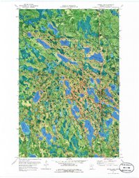
1970 Map of Spring Lake
USGS Topo · Published 1986About this map
Big Fork State Forest and the Chippewa National Forest converge in this northern Minnesota landscape, defined by an intricate network of glacial lakes and wetlands. The hydrography, compiled by the Minnesota Department of Conservation, reveals a dense cluster of named water bodies like Arrowhead Lake, Too Much Lake, and Lac-a-Roy Lake. The presence of several Gravel Pits and an Old Railroad Grade snaking through the western section suggests a history tied to resource extraction and timber transport rather than large-scale residential settlement.
Find a feature on this map
48 named features on this map. Tap any name to fly to it.
Don’t see what you’re looking for? This feature index may not catch every label — zoom into the map to look around manually.
Map Details
Editions of this 1970 Spring Lake Map
2 editions found
Other maps of this area

1918 · Zora
USGS Topo · 1:62,500

1919 · Zora
USGS Topo · 1:62,500

1919 · Marcell
USGS Topo · 1:62,500

1954 · Hibbing
USGS Topo · 1:250,000

1957 · Hibbing
USGS Topo · 1:250,000

1958 · Hibbing
USGS Topo · 1:250,000

1964 · Hibbing
USGS Topo · 1:250,000

1970 · Bowstring Lake
USGS Topo · 1:24,000

1970 · Jessie Lake
USGS Topo · 1:24,000
1970 · Spring Lake
USGS Topo · 1:24,000