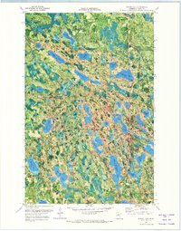
1970 Map of Spring Lake
USGS Topo · Published 1973About this map
Big Fork State Forest and Chippewa National Forest meet in this 1970s orthophotomap, showing a dense network of water and timberland in Itasca County. The landscape is defined by its glacial lakes, from the large Spring Lake and Lac-a-Roy Lake to smaller bodies like Boggy Lake and the Ackerman Lakes. This survey uses an aerial photography base to highlight the transition between the forests and the early industrial or recreational infrastructure of the area, including the Riverside Chapel and Mt Tabor Camp.
Find a feature on this map
50 named features on this map. Tap any name to fly to it.
Don’t see what you’re looking for? This feature index may not catch every label — zoom into the map to look around manually.
Map Details
Editions of this 1970 Spring Lake Map
2 editions found
Other maps of this area

1918 · Zora
USGS Topo · 1:62,500

1919 · Zora
USGS Topo · 1:62,500

1919 · Marcell
USGS Topo · 1:62,500

1954 · Hibbing
USGS Topo · 1:250,000

1957 · Hibbing
USGS Topo · 1:250,000

1958 · Hibbing
USGS Topo · 1:250,000

1964 · Hibbing
USGS Topo · 1:250,000

1970 · Bowstring Lake
USGS Topo · 1:24,000

1970 · Jessie Lake
USGS Topo · 1:24,000
1970 · Bigfork
USGS Topo · 1:24,000