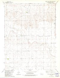
1979 Map of Spring Valley Ranch
USGS Topo · Published 1980About this map
Spring Valley Ranch sits at the heart of this Western Kansas landscape, illustrating the remote ranching and agricultural patterns of Wallace County in the late 1970s. The terrain is defined by the drainage basins of Eagletail Creek and Ladder Creek, which carve subtle valleys across the high plains. Human infrastructure is sparse but functional, centered on utility and community as seen at the Dover Grange Hall and the local Substation. Industrial activity is marked by scattered Gravel Pits and a Pumping Station alongside a significant Pipeline that traverses the northern sections. This survey, updated from earlier aerial photography, documents a period of stable land use where water management via numerous Wells remained critical for sustaining the ranching operations in this semi-arid region.
Find a feature on this map
12 named features on this map. Tap any name to fly to it.
Don’t see what you’re looking for? This feature index may not catch every label — zoom into the map to look around manually.
Map Details
Editions of this 1979 Spring Valley Ranch Map
This is the sole edition of this map. No revisions or reprints were ever made.
Other maps of this area

1955 · Scott City
USGS Topo · 1:250,000

1958 · Scott City
USGS Topo · 1:250,000

1959 · Weskan
USGS Topo · 1:62,500

1959 · Wallace
USGS Topo · 1:62,500

1968 · Sharon Springs 3 NE
USGS Topo · 1:24,000

1968 · Sharon Springs 4 NW
USGS Topo · 1:24,000

1968 · Sharon Springs 3 NW
USGS Topo · 1:24,000
1979 · Sharon Springs West
USGS Topo · 1:24,000
1979 · Sharon Springs East
USGS Topo · 1:24,000
1979 · Weskan
USGS Topo · 1:24,000