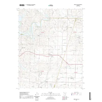
2020 Map of Spring Valley
USGS Topo · Published 2020About this map
Spring Valley sits at the heart of this landscape where the Ozark Plateau begins to yield to the drainage basins of the White River system. The terrain is defined by the winding course of War Eagle Creek, which carves through the landscape near Martin Bluff and eventually feeds into Beaver Lake in the northwest. This area serves as a transition between the more developed corridors of Washington County and the deeply incised hollows like Hickory Flat Hollow and Granny Hollow.
Find a feature on this map
123 named features on this map. Tap any name to fly to it.
Don’t see what you’re looking for? This feature index may not catch every label — zoom into the map to look around manually.
Map Details
Editions of this 2020 Spring Valley Map
This is the sole edition of this map. No revisions or reprints were ever made.
Other maps of this area

1899 · Fayetteville
USGS Topo · 1:125,000

1900 · Eureka Springs
USGS Topo · 1:125,000

1901 · Eureka Springs
USGS Topo · 1:125,000

1901 · Fayetteville
USGS Topo · 1:125,000

1904 · Fayetteville
USGS Topo · 1:125,000

1945 · Harrison
USGS Topo · 1:250,000

1949 · Harrison
USGS Topo · 1:250,000

1954 · Harrison
USGS Topo · 1:250,000

1954 · Tulsa
USGS Topo · 1:250,000

1957 · Mundell
USGS Topo · 1:24,000