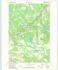
1971 Map of Springbrook
USGS Topo · Published 1974About this map
The Namekagon River winds through this 1970s landscape, serving as a central corridor for the Chicago and North Western railroad. The settlement of Springbrook serves as a local focal point, supported by nearby landmarks like St Lukes Cem and the Mackay Valley Ch to the south. The terrain is defined by a dense network of wetlands and water bodies, ranging from the large Gull Lake in the northwest to specialized features like the Cranberry Bog and Savage Springs. Significant conservation and land management are evident in the Bean Brook State Wildlife Management Area, which protects the winding course of Bean Brook. This survey provides a look at the intersection of wild north-woods hydrology and the established infrastructure of rural Washburn County, showing numerous gravel pits and public access boat ramps that point to a local economy tied to both extraction and outdoor recreation.
Find a feature on this map
38 named features on this map. Tap any name to fly to it.
Don’t see what you’re looking for? This feature index may not catch every label — zoom into the map to look around manually.
Map Details
Editions of this 1971 Springbrook Map
This is the sole edition of this map. No revisions or reprints were ever made.
Other maps of this area

1947 · Chittamo
USGS Topo · 1:48,000

1947 · Minong
USGS Topo · 1:48,000

1948 · Spooner
USGS Topo · 1:48,000

1948 · Stone Lake
USGS Topo · 1:48,000

1949 · Chittamo
USGS Topo · 1:48,000

1949 · Minong
USGS Topo · 1:48,000

1949 · Spooner
USGS Topo · 1:48,000

1950 · Stone Lake
USGS Topo · 1:48,000

1953 · Ashland
USGS Topo · 1:250,000

1953 · Rice Lake
USGS Topo · 1:250,000