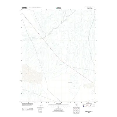
2012 Map of Springdale NW
USGS Topo · Published 2012About this map
Sarcobatus Flat dominates this desert landscape in southern Nevada, where dry drainage networks converge in a wide alluvial basin. The 2012 survey by the U.S. Geological Survey shows a stark terrain defined by the intermittent Tolicha Wash as it winds through the arid floor. This corner of Nye County is punctuated by the rising slopes of Coba Mountain to the southeast, providing a clear illustration of the Great Basin's basin-and-range topography. Modern transportation is represented by the diagonal corridor of Highway 95, which serves as the primary artery through this sparsely developed region. The map captures the specialized hydrology of the high desert, where topographic detail reveals the intricate flow patterns of seasonal washes across the flats.
Find a feature on this map
4 named features on this map. Tap any name to fly to it.
Don’t see what you’re looking for? This feature index may not catch every label — zoom into the map to look around manually.
Map Details
Editions of this 2012 Springdale NW Map
This is the sole edition of this map. No revisions or reprints were ever made.
Other maps of this area

1908 · Kawich
USGS Topo · 1:250,000

1908 · Lida
USGS Topo · 1:250,000

1913 · Lida
USGS Topo · 1:250,000

1942 · Tolicha Peak
USGS Topo · 1:125,000

1954 · Goldfield
USGS Topo · 1:250,000

1955 · Goldfield
USGS Topo · 1:250,000

1958 · Goldfield
USGS Topo · 1:250,000

1962 · Goldfield
USGS Topo · 1:250,000
1966 · Springdale
USGS Topo · 1:62,500
1967 · Bonnie Claire SE
USGS Topo · 1:24,000