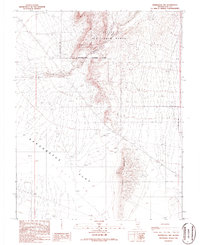
1986 Map of Springdale NW
USGS Topo · Published 1986About this map
Nellis Air Force Range dominates the northern and eastern portions of this 1980s-era landscape, where military operations and environmental extremes meet. A designated Restricted Access Area buffers the high ground of Tolicha Peak, while the southeastern corner is defined by the steep elevation of Coba Mountain. Below these peaks, the terrain drops into the vast arid basins of the Sarcobatus Depression and a large Alkali Flat. The infrastructure of the mid-1980s is sparse, primarily consisting of a Trans Line and an isolated Gravel Pit. The map captures a moment of transition in Nye County, showing the intersection of federal defense land use and the natural geological features of the high desert before further modernization.
Find a feature on this map
11 named features on this map. Tap any name to fly to it.
Don’t see what you’re looking for? This feature index may not catch every label — zoom into the map to look around manually.
Map Details
Editions of this 1986 Springdale NW Map
This is the sole edition of this map. No revisions or reprints were ever made.
Other maps of this area

1908 · Kawich
USGS Topo · 1:250,000

1908 · Lida
USGS Topo · 1:250,000

1913 · Lida
USGS Topo · 1:250,000

1942 · Tolicha Peak
USGS Topo · 1:125,000

1954 · Goldfield
USGS Topo · 1:250,000

1955 · Goldfield
USGS Topo · 1:250,000

1958 · Goldfield
USGS Topo · 1:250,000

1962 · Goldfield
USGS Topo · 1:250,000
1966 · Springdale
USGS Topo · 1:62,500
1967 · Bonnie Claire SE
USGS Topo · 1:24,000