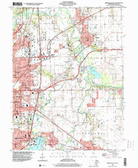
1998 Map of Springfield East
USGS Topo · Published 2000About this map
The Sangamon River meanders across this eastern portion of the Illinois state capital, defining the transition between the urbanized grid of Springfield and the agricultural lands of Clear Lake Twp. Significant institutional and military footprints are evident, including the sprawling grounds of Camp Lincoln and the US Naval Training Sta near Lake Springfield. The map serves as a vital record for family researchers, detailing numerous burial sites such as the large Roselawn Memorial Cemetery and the more historical Camp Butler Cem. Transportation networks dominated by the Illinois Central RR and Norfolk and Western RR intersect with suburban developments like Arlington Heights and Grandview. Industrial elements including a Mine Dump and various Claypit extractions indicate the region's extraction history, while the Spaulding Dam regulates the water levels for the city's namesake lake.
Find a feature on this map
77 named features on this map. Tap any name to fly to it.
Don’t see what you’re looking for? This feature index may not catch every label — zoom into the map to look around manually.
Map Details
Editions of this 1998 Springfield East Map
This is the sole edition of this map. No revisions or reprints were ever made.
Other maps of this area

1907 · Springfield
USGS Topo · 1:62,500

1922 · Divernon
USGS Topo · 1:62,500

1923 · Taylorville
USGS Topo · 1:62,500

1924 · Divernon
USGS Topo · 1:62,500

1925 · Taylorville
USGS Topo · 1:62,500

1930 · Springfield
USGS Topo · 1:62,500

1940 · Springfield
USGS Topo · 1:62,500

1950 · Springfield West
USGS Topo · 1:24,000

1950 · Springfield East
USGS Topo · 1:24,000

1954 · Mechanicsburg
USGS Topo · 1:62,500