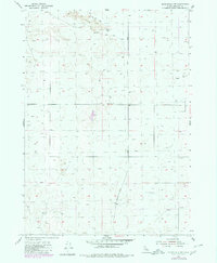
1955 Map of Springfield NW
USGS Topo · Published 1980About this map
The volcanic terrain of Lava dominates the northern landscape of this Bingham County survey, reflecting the geological history of the Snake River Plain. Settlement is sparse, defined by the long north-south corridor of Springfield Taber Road and a dispersed network of agricultural infrastructure. Water management is the primary human footprint here, visible in the dozens of wells and occasional windmills scattered across the township lines. A Monument stands near the eastern border, while a small Borrow Pit in the southeast indicates local extraction activities. This area represents a post-war ranching landscape where infrastructure was vital for reclaiming the arid land between the basalt fields.
Find a feature on this map
6 named features on this map. Tap any name to fly to it.
Don’t see what you’re looking for? This feature index may not catch every label — zoom into the map to look around manually.
Map Details
Editions of this 1955 Springfield NW Map
2 editions found
Other maps of this area

1955 · Springfield NW
USGS Topo · 1:24,000

1955 · Rockford
USGS Topo · 1:24,000

1955 · Pingree
USGS Topo · 1:24,000

1955 · Springfield
USGS Topo · 1:24,000

1955 · Idaho Falls
USGS Topo · 1:250,000

1958 · Idaho Falls
USGS Topo · 1:250,000

1973 · Olsen
USGS Topo · 1:24,000

1973 · Taber
USGS Topo · 1:24,000

1973 · Lava Lake Reservoir
USGS Topo · 1:24,000

1973 · Coffee Point NE
USGS Topo · 1:24,000