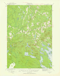
1931 Map of Springfield
USGS Topo · Published 1958About this map
The town of Springfield and the neighboring settlements of Prentiss and Carroll anchor this landscape of the Maine interior during the early 1930s. The map illustrates a network of rural schoolhouses that once served these dispersed communities, including the Webster Sch, Tolman Sch, and Washington Sch. Navigation through the thick woods and numerous ridges is defined by the Mattawamkeag River West Branch and the prominent Dill Fire Tower, which stands watch over the surrounding elevations of Lombard Mountain and Bear Mountain. To the south, the expansive waters of Sysladobsis Lake and Lombard Lake dominate the terrain, connected by a system of smaller ponds and streams like Upper Pug Lake. This survey captures the region just as aerial photography, provided here by the Army Air Corps, began to refine the precision of topographic mapping in the Maine woods.
Find a feature on this map
124 named features on this map. Tap any name to fly to it.
Don’t see what you’re looking for? This feature index may not catch every label — zoom into the map to look around manually.
Map Details
Editions of this 1931 Springfield Map
4 editions found
Other maps of this area

1920 · Winn
USGS Topo · 1:62,500

1931 · Springfield
USGS Topo · 1:48,000

1931 · Saponac
USGS Topo · 1:48,000

1932 · Nicatous Lake
USGS Topo · 1:48,000

1934 · Saponac
USGS Topo · 1:62,500

1934 · Nicatous Lake
USGS Topo · 1:62,500

1934 · Springfield
USGS Topo · 1:62,500

1940 · Danforth
USGS Topo · 1:62,500

1940 · Mattawamkeag
USGS Topo · 1:62,500

1941 · Danforth
USGS Topo · 1:62,500