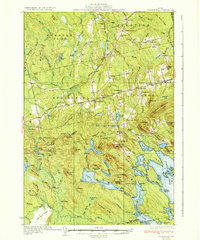
1934 Map of Springfield
USGS Topo · Published 1934About this map
Springfield and its surrounding townships define this 1930s landscape of eastern Penobscot County, where small rural settlements are linked by Route 170 and Route 169. The era's educational infrastructure is exceptionally well-documented, with numerous country schools like Tolman Sch, White Sch, and Cole Sch serving the local farming and timber families. A network of ridges, including Tucker Ridge and Sheepskin Ridge, separates the northern agricultural clearings from the extensive water systems to the south.
Find a feature on this map
129 named features on this map. Tap any name to fly to it.
Don’t see what you’re looking for? This feature index may not catch every label — zoom into the map to look around manually.
Map Details
Editions of this 1934 Springfield Map
4 editions found
Other maps of this area

1920 · Winn
USGS Topo · 1:62,500

1931 · Springfield
USGS Topo · 1:48,000

1931 · Saponac
USGS Topo · 1:48,000

1932 · Nicatous Lake
USGS Topo · 1:48,000

1934 · Saponac
USGS Topo · 1:62,500

1934 · Nicatous Lake
USGS Topo · 1:62,500

1934 · Springfield
USGS Topo · 1:62,500

1940 · Danforth
USGS Topo · 1:62,500

1940 · Mattawamkeag
USGS Topo · 1:62,500

1941 · Danforth
USGS Topo · 1:62,500