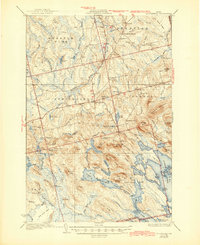
1934 Map of Springfield
USGS Topo · Published 1945About this map
Springfield serves as the primary hub of this eastern Maine landscape, where the town center and South Springfield anchor a network of rural schools and isolated farms. The settlement pattern is defined by family-named landmarks and local institutions, including the Webster Sch, Tolman Sch, and White Sch, reflecting a time when education was decentralized across these townships. Beyond the cleared fields of Drake Place and Budge Farm, the terrain transitions into a complex lake system dominated by Upper Sysladobsis Lake and Junior Lake. A Fire Tower stands atop Dill Ridge, overseeing the timberlands and interconnected waterways like Bottle Lake and Duck Lake. This 1930s survey captures the region's character as a blend of small-scale agriculture and the burgeoning recreation industry, seen at Bayview Camp.
Find a feature on this map
114 named features on this map. Tap any name to fly to it.
Don’t see what you’re looking for? This feature index may not catch every label — zoom into the map to look around manually.
Map Details
Editions of this 1934 Springfield Map
4 editions found
Other maps of this area

1920 · Winn
USGS Topo · 1:62,500

1931 · Springfield
USGS Topo · 1:48,000

1931 · Saponac
USGS Topo · 1:48,000

1932 · Nicatous Lake
USGS Topo · 1:48,000

1934 · Saponac
USGS Topo · 1:62,500

1934 · Nicatous Lake
USGS Topo · 1:62,500

1934 · Springfield
USGS Topo · 1:62,500

1940 · Danforth
USGS Topo · 1:62,500

1940 · Mattawamkeag
USGS Topo · 1:62,500

1941 · Danforth
USGS Topo · 1:62,500