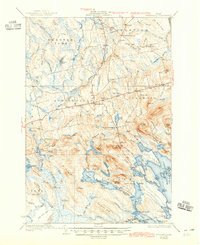
1934 Map of Springfield
USGS Topo · Published 1945About this map
The Mattawamkeag River and its West Branch carve through a landscape of ridges and low-lying wetlands in this pre-war survey of Penobscot County. The village of Springfield serves as a central hub, surrounded by smaller communities like Carroll and Prentiss. This era represents a time when rural life revolved around a dense network of local education, evidenced by more than ten distinct schoolhouses such as Gates Sch, Webster Sch, and Cole Sch. To the south, the terrain transitions into a complex system of interconnected waters including Sysladobsis Lake and Lombard Lake. Local industry and agriculture are represented by features like Oak Min and family-held lands such as Budge Farm and Curry Farm, providing a detailed look at the human footprint within the Maine woods before mid-century modernization.
Find a feature on this map
125 named features on this map. Tap any name to fly to it.
Don’t see what you’re looking for? This feature index may not catch every label — zoom into the map to look around manually.
Map Details
Editions of this 1934 Springfield Map
4 editions found
Other maps of this area

1920 · Winn
USGS Topo · 1:62,500

1931 · Springfield
USGS Topo · 1:48,000

1931 · Saponac
USGS Topo · 1:48,000

1932 · Nicatous Lake
USGS Topo · 1:48,000

1934 · Saponac
USGS Topo · 1:62,500

1934 · Nicatous Lake
USGS Topo · 1:62,500

1934 · Springfield
USGS Topo · 1:62,500

1940 · Danforth
USGS Topo · 1:62,500

1940 · Mattawamkeag
USGS Topo · 1:62,500

1941 · Danforth
USGS Topo · 1:62,500