
1946 Map of Springville
USGS Topo · Published 1971About this map
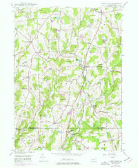
The Lehigh Valley railroad cuts through the heart of this Susquehanna County landscape, connecting the rural communities of Springville and Dimock. The map reveals a mid-century agricultural economy defined by small settlements and family-named landmarks. North of Meshoppen Creek, industry is represented by the States Mill near States Mill Pond, while educational and community life is anchored by sites like the Wallace Hill Sch and several local burial grounds including Lynn Cem and Quick Cem.
Find a feature on this map
59 named features on this map. Tap any name to fly to it.
Don’t see what you’re looking for? This feature index may not catch every label — zoom into the map to look around manually.
Map Details
Editions of this 1946 Springville Map
2 editions found
Other maps of this area

1943 · Montrose
USGS Topo · 1:62,500

1943 · Le Raysville
USGS Topo · 1:62,500

1945 · Montrose
USGS Topo · 1:62,500

1945 · Le Raysville
USGS Topo · 1:62,500

1945 · Meshoppen
USGS Topo · 1:62,500

1945 · Auburn Center
USGS Topo · 1:24,000

1945 · Meshoppen
USGS Topo · 1:24,000

1946 · Tunkhannock
USGS Topo · 1:62,500

1946 · Factoryville
USGS Topo · 1:24,000

1946 · Hop Bottom
USGS Topo · 1:24,000