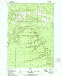
1989 Map of Sprinkler Lake
USGS Topo · Published 1989About this map
Huron National Forest and Au Sable State Forest define the landscape of this northern Michigan region near the border of Alcona and Iosco Counties. The terrain is characterized by a complex network of waterways, including the South Branch Pine River and Vandercook Creek, which carve through the townships of Millen and Mikado. In addition to the primary Sprinkler Lake, several smaller water bodies like Deter Lake are scattered throughout the forested tracts. The infrastructure reflects the area's recreational and resource-based utility in the late 1980s, featuring multiple gravel pits and an extensive system of forest routes such as Rearing Pond Trail and Snowmobile Trail. Local transit is facilitated by rural connectors like Mikado-Glennie Road and Hubbard Lake Road, which link the various forest compartments and private holdings.
Find a feature on this map
32 named features on this map. Tap any name to fly to it.
Don’t see what you’re looking for? This feature index may not catch every label — zoom into the map to look around manually.
Map Details
Editions of this 1989 Sprinkler Lake Map
This is the sole edition of this map. No revisions or reprints were ever made.
Other maps of this area

1954 · Tawas City
USGS Topo · 1:250,000

1958 · Tawas City
USGS Topo · 1:250,000

1959 · Tawas City
USGS Topo · 1:62,500

1959 · East Tawas
USGS Topo · 1:62,500

1959 · Glennie
USGS Topo · 1:62,500

1959 · Harrisville
USGS Topo · 1:62,500

1983 · Hubbard Lake
USGS Topo · 1:100,000

1984 · Tawas City
USGS Topo · 1:100,000
1989 · Barton City
USGS Topo · 1:24,000

1989 · Mikado
USGS Topo · 1:24,000