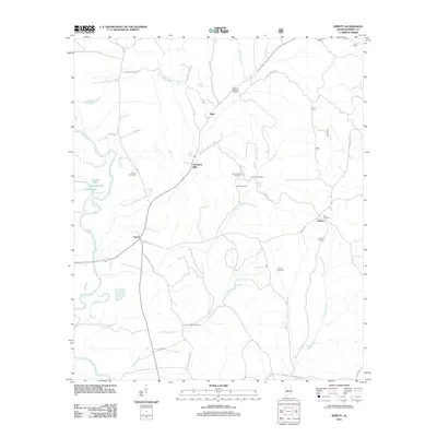
2011 Map of Sprott
USGS Topo · Published 2011About this map
The Cahaba River winds through this central Alabama landscape, defining a terrain of river bottoms and interconnected waterways. The settlement of Sprott serves as a local hub where several county highways converge, including Co Hwy 49 and Co Hwy 10. Further north, the legacy of local industry is marked by Cleveland Mills situated along Mill Creek.
Find a feature on this map
37 named features on this map. Tap any name to fly to it.
Don’t see what you’re looking for? This feature index may not catch every label — zoom into the map to look around manually.
Map Details
Editions of this 2011 Sprott Map
This is the sole edition of this map. No revisions or reprints were ever made.
Other maps of this area

1953 · Montgomery
USGS Topo · 1:250,000

1956 · Montgomery
USGS Topo · 1:250,000

1957 · Montgomery
USGS Topo · 1:250,000

1959 · Summerfield
USGS Topo · 1:62,500

1975 · Summerfield SW
USGS Topo · 1:24,000
1975 · Summerfield SE
USGS Topo · 1:24,000

1979 · Marion North
USGS Topo · 1:24,000

1979 · Marion South
USGS Topo · 1:24,000

1979 · Harrisburg
USGS Topo · 1:24,000
1980 · Oakmulgee
USGS Topo · 1:24,000