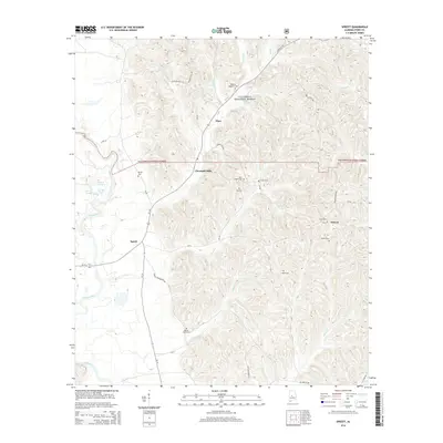
2014 Map of Sprott
USGS Topo · Published 2014About this map
The Cahaba River winds through the western reaches of this Perry County landscape, marking a transition between the river lowlands and the uplands of the Talladega National Forest. This 2014 survey documents a rural Alabama corridor defined by small settlements like Sprott and Cleveland Mills, where local life is anchored by family-named landmarks and long-established burial grounds. For genealogists, the map is a significant record of family history, noting numerous sites such as the Dobyne Haggard Cem, Iveys Chapel Cem, and Barron Wells Cem. The terrain is deeply etched by a network of tributaries including Camp Branch, Mill Cr, and Wells Cr, which feed into the larger river system. To the east, the community of Osborn sits at the junction of CR-32 and Pryor Bottom Rd, surrounded by the Osburn Cem and Farrer Cem, illustrating the persistent footprint of legacy families in the region.
Find a feature on this map
46 named features on this map. Tap any name to fly to it.
Don’t see what you’re looking for? This feature index may not catch every label — zoom into the map to look around manually.
Map Details
Editions of this 2014 Sprott Map
This is the sole edition of this map. No revisions or reprints were ever made.
Other maps of this area

1953 · Montgomery
USGS Topo · 1:250,000

1956 · Montgomery
USGS Topo · 1:250,000

1957 · Montgomery
USGS Topo · 1:250,000

1959 · Summerfield
USGS Topo · 1:62,500

1975 · Summerfield SW
USGS Topo · 1:24,000
1975 · Summerfield SE
USGS Topo · 1:24,000

1979 · Marion North
USGS Topo · 1:24,000

1979 · Marion South
USGS Topo · 1:24,000

1979 · Harrisburg
USGS Topo · 1:24,000
1980 · Oakmulgee
USGS Topo · 1:24,000