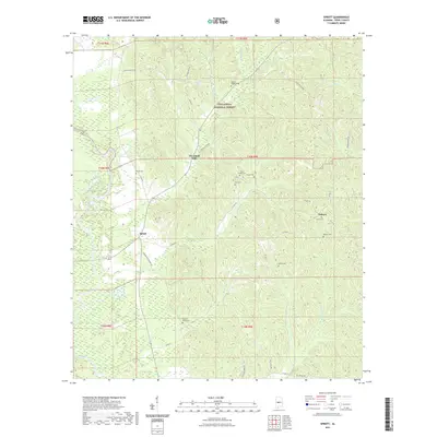
2021 Map of Sprott
USGS Topo · Published 2021About this map
Sprott and the surrounding woodlands of Perry County define this landscape along the eastern edge of the Talladega National Forest. The map provides a detailed view of several crossroads communities including Cleveland Mills and Osborn, connected by a network of rural routes like Pryor Bottom Rd and Hudson Huey Rd. The area is notably dense with family and community burial grounds, such as the Farrer Cem, Osburn Cem, and the Dobyne-Haggard Cem, which serve as vital markers for local genealogical research. In the southwest, the Cahaba River winds through the terrain, joined by numerous tributaries including Wells Cr and Waters Cr, illustrating the well-watered topography of central Alabama. These features together show a resilient rural settlement pattern that persists into the early twenty-first century.
Find a feature on this map
47 named features on this map. Tap any name to fly to it.
Don’t see what you’re looking for? This feature index may not catch every label — zoom into the map to look around manually.
Map Details
Editions of this 2021 Sprott Map
This is the sole edition of this map. No revisions or reprints were ever made.
Other maps of this area

1953 · Montgomery
USGS Topo · 1:250,000

1956 · Montgomery
USGS Topo · 1:250,000

1957 · Montgomery
USGS Topo · 1:250,000

1959 · Summerfield
USGS Topo · 1:62,500

1975 · Summerfield SW
USGS Topo · 1:24,000
1975 · Summerfield SE
USGS Topo · 1:24,000

1979 · Marion North
USGS Topo · 1:24,000

1979 · Marion South
USGS Topo · 1:24,000

1979 · Harrisburg
USGS Topo · 1:24,000
1980 · Oakmulgee
USGS Topo · 1:24,000