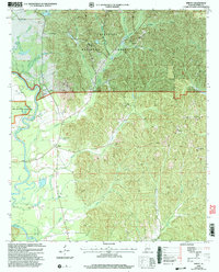
2002 Map of Sprott
USGS Topo · Published 2004About this map
The Cahaba River winds through the western edge of this landscape, its banks home to the Marion National Fish Hatchery and a series of oxbow features including Round Lake, Middle Lake, and Perry Lake. To the east, the topography transitions into the protected timberlands of the Talladega National Forest, where a network of creek branches like Mill Creek and Stone Creek drain the upland ridges. Local life at the turn of the 21st century remains anchored by rural nodes like Sprott and Cleveland Mills. Genealogists and local historians can trace the foundations of the community through several country churches and school sites, such as Prowell Sch and Iveys Chapel, along with various Gravel Pit operations that speak to the area's geological and extractive utility.
Find a feature on this map
33 named features on this map. Tap any name to fly to it.
Don’t see what you’re looking for? This feature index may not catch every label — zoom into the map to look around manually.
Map Details
Editions of this 2002 Sprott Map
This is the sole edition of this map. No revisions or reprints were ever made.
Other maps of this area

1953 · Montgomery
USGS Topo · 1:250,000

1956 · Montgomery
USGS Topo · 1:250,000

1957 · Montgomery
USGS Topo · 1:250,000

1959 · Summerfield
USGS Topo · 1:62,500

1975 · Summerfield SW
USGS Topo · 1:24,000
1975 · Summerfield SE
USGS Topo · 1:24,000

1979 · Marion North
USGS Topo · 1:24,000

1979 · Marion South
USGS Topo · 1:24,000

1979 · Harrisburg
USGS Topo · 1:24,000
1980 · Oakmulgee
USGS Topo · 1:24,000