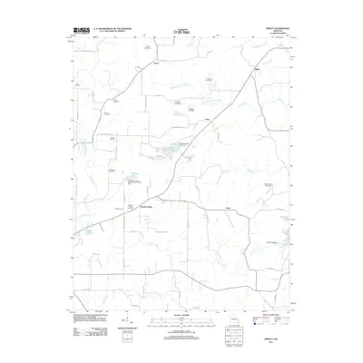
2011 Map of Sprott
USGS Topo · Published 2011About this map
Chestnut Ridge serves as a prominent geographic and community anchor in this part of Ste. Genevieve County, defined by a network of rural roads and scattered small settlements. The landscape is dotted with family and community burial grounds, including Doss Cemetery, McGee Cemetery, and Oakland Cemetery, reflecting generations of local residency. Water management is a defining characteristic of the terrain, as evidenced by numerous private and community impoundments such as Lake Genevieve, Tragden Lake, and Pineview Lake. The drainage patterns of Jonca Creek and Sand Creek carve through the countryside, influencing the placement of early homesteads and road crossings. Small hubs like Sprott, Jonca, and Pickel represent the enduring rural centers of the area, while the presence of the Sainte Genevieve Sportsman Club Lake Dam suggests a history of local recreation and land use tied to the region's natural resources.
Find a feature on this map
70 named features on this map. Tap any name to fly to it.
Don’t see what you’re looking for? This feature index may not catch every label — zoom into the map to look around manually.
Map Details
Editions of this 2011 Sprott Map
This is the sole edition of this map. No revisions or reprints were ever made.
Other maps of this area

1904 · Farmington
USGS Topo · 1:62,500

1906 · Farmington
USGS Topo · 1:62,500

1907 · Weingarten
USGS Topo · 1:62,500

1909 · Weingarten
USGS Topo · 1:62,500

1910 · Higdon
USGS Topo · 1:62,500

1939 · Fredericktown
USGS Topo · 1:48,000

1947 · Fredericktown
USGS Topo · 1:62,500

1949 · Rolla
USGS Topo · 1:250,000

1950 · Fredericktown
USGS Topo · 1:62,500

1953 · Rolla
USGS Topo · 1:250,000