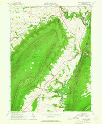
1963 Map of Spruce Creek
USGS Topo · Published 1965About this map
Etna Furnace and Union Furnace stand as markers of the region's industrial heritage where the Frankstown Branch meets the mountains. The landscape is defined by the dramatic ridges of Brush Mountain, Canoe Mountain, and Tussey Mountain, which funnel settlement into the productive lowlands of Sinking Valley and Canoe Valley. The Pennsylvania Railroad and the Pennsylvania River provide the primary transport corridors, connecting small communities like Pemberton and Shaffersville. Local history is preserved in the placement of the Sinking Valley Ch and St John Cem, while the limestone geology is evident in the numerous quarries and the name of Arch Spring. Significant portions of the uplands are dedicated to conservation through State Game Lands No 166 and the Rothrock State Forest, maintaining the wilderness character of the higher elevations.
Find a feature on this map
40 named features on this map. Tap any name to fly to it.
Don’t see what you’re looking for? This feature index may not catch every label — zoom into the map to look around manually.
Map Details
Editions of this 1963 Spruce Creek Map
4 editions found
Other maps of this area

1901 · Huntingdon
USGS Topo · 1:62,500

1902 · Hollidaysburg
USGS Topo · 1:62,500

1903 · Hollidaysburg
USGS Topo · 1:62,500

1904 · Huntingdon
USGS Topo · 1:62,500

1920 · Altoona
USGS Topo · 1:62,500

1922 · Altoona
USGS Topo · 1:62,500

1923 · Tyrone
USGS Topo · 1:62,500

1929 · Tyrone
USGS Topo · 1:48,000

1933 · Tyrone
USGS Topo · 1:62,500

1946 · Tyrone
USGS Topo · 1:62,500
Featured Places
- Frankstown Township, PA
- Spruce Creek Township, PA
- Shaffersville, Morris Township
- Tyrone Township, PA
- Catharine Township, PA