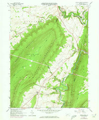
1963 Map of Spruce Creek
USGS Topo · Published 1973About this map
The Juniata River and its Frankstown Branch carve through the deep ridges of central Pennsylvania, defining a landscape shaped by early industry and narrow valley settlements. This 1963 survey captures the remnants of the region's iron-making heritage at Etna Furnace and Union Furnace, where the proximity of limestone and water power once fueled local production. The rugged terrain of Canoe Mountain and Brush Mountain separates the fertile agricultural lands of Sinking Valley from the river corridors. Throughout the map, the tracks of the Penn Central railroad follow the river's path, connecting small communities like Shaffersville and Water Street. Genealogists and local historians can locate early landmarks such as the Sinking Valley Ch and St John Cem, along with the distinctive Arch Spring, which highlights the complex hydrology of this karst landscape.
Find a feature on this map
39 named features on this map. Tap any name to fly to it.
Don’t see what you’re looking for? This feature index may not catch every label — zoom into the map to look around manually.
Map Details
Editions of this 1963 Spruce Creek Map
4 editions found
Other maps of this area

1901 · Huntingdon
USGS Topo · 1:62,500

1902 · Hollidaysburg
USGS Topo · 1:62,500

1903 · Hollidaysburg
USGS Topo · 1:62,500

1904 · Huntingdon
USGS Topo · 1:62,500

1920 · Altoona
USGS Topo · 1:62,500

1922 · Altoona
USGS Topo · 1:62,500

1923 · Tyrone
USGS Topo · 1:62,500

1929 · Tyrone
USGS Topo · 1:48,000

1933 · Tyrone
USGS Topo · 1:62,500

1946 · Tyrone
USGS Topo · 1:62,500
Featured Places
- Frankstown Township, PA
- Spruce Creek Township, PA
- Shaffersville, Morris Township
- Tyrone Township, PA
- Catharine Township, PA