
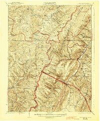
1924 Map of Spruce Knob
USGS Topo · Published 1924About this map
Allegheny Mountains terrain dominates this 1924 study, defined by the towering heights of Spruce Knob and the complex drainage of the North Fork River. The landscape reveals a network of high-elevation mountain communities and natural curiosities, including the limestone karst features of The Sinks near Osceola PO and the mysterious The Burning on the slopes of Spruce Mountain. Transportation is centered on the W V C & P RR and C & O RR corridor near Thornwood PO and Whitmer Sta.
Find a feature on this map
114 named features on this map. Tap any name to fly to it.
Don’t see what you’re looking for? This feature index may not catch every label — zoom into the map to look around manually.
Map Details
Editions of this 1924 Spruce Knob Map
2 editions found
Other maps of this area

1889 · Beverly
USGS Topo · 1:125,000

1892 · Beverly
USGS Topo · 1:125,000

1892 · Franklin
USGS Topo · 1:125,000

1894 · Staunton
USGS Topo · 1:125,000

1896 · Franklin
USGS Topo · 1:125,000

1901 · Monterey
USGS Topo · 1:125,000

1909 · Elkins
USGS Topo · 1:62,500

1920 · Onego
USGS Topo · 1:62,500

1921 · Onego
USGS Topo · 1:48,000

1922 · Onego
USGS Topo · 1:62,500