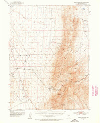
1953 Map of Spruce Mountain
USGS Topo · Published 1955About this map
Spruce Mountain dominates the landscape of this 1950s survey, a prominent high-desert ridge rising between Clover Valley and Independence Valley. The eastern slopes of the mountain reveal a concentrated history of extraction, with numerous workings including the Black Forest Mine, Kille Mine, and Monarch Mine. Near the southern peaks, the Sprucemont (Site) indicates a former habitation area supported by local water sources like Townsite Spring. This mining district relied on a network of remote infrastructure, from the Spruce Mountain Road to scattered resources such as the Basco Spring Water Tank and Spruce Well. The map captures the industrial footprint of high-altitude Nevada mining before modern large-scale redevelopment, documenting the specific locations of shafts, gravel pits, and prospects that defined the local economy during the mid-twentieth century.
Find a feature on this map
27 named features on this map. Tap any name to fly to it.
Don’t see what you’re looking for? This feature index may not catch every label — zoom into the map to look around manually.
Map Details
Editions of this 1953 Spruce Mountain Map
4 editions found
Other maps of this area

1935 · Halleck
USGS Topo · 1:125,000

1953 · Spruce Mountain
USGS Topo · 1:62,500

1953 · Spruce Mountain 4
USGS Topo · 1:62,500

1955 · Elko
USGS Topo · 1:250,000

1958 · Elko
USGS Topo · 1:250,000

1962 · Elko
USGS Topo · 1:250,000

1965 · Elko
USGS Topo · 1:250,000

1968 · Independence Valley SW
USGS Topo · 1:24,000

1968 · Snow Water Lake
USGS Topo · 1:24,000

1968 · Ventosa
USGS Topo · 1:24,000