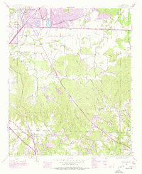
1945 Map of Spruce Pine
USGS Topo · Published 1977About this map
Spruce Pine and the southern outskirts of Russellville define this 1945 landscape, captured as the region balanced its agricultural roots with industrial expansion. The terrain is marked by a complex network of hollows and ridges, including Suggs Mtn and Horsemill Mtn, where numerous small drainage branches like Wilson Creek and Kennedy Branch feed into the larger Cedar Creek system. The area's mid-century infrastructure is anchored by the Southern railroad and the Jackson Highway, which connect established settlements like Reedtown and Newtown. Social life for local families revolved around community landmarks such as Cedar Grove Ch, Mt Olive Ch, and several neighborhood schools including Hurricane Sch and Sloss Sch. Heavy industry is evidenced by a Strip Mine and the significant Sloss Lake reservoir, reflecting the extractive economy that shaped northern Alabama during this era.
Find a feature on this map
50 named features on this map. Tap any name to fly to it.
Don’t see what you’re looking for? This feature index may not catch every label — zoom into the map to look around manually.
Map Details
Editions of this 1945 Spruce Pine Map
3 editions found

Other maps of this area

1924 · Tuscumbia
USGS Topo · 1:48,000

1925 · Barton
USGS Topo · 1:62,500

1926 · Tuscumbia
USGS Topo · 1:62,500

1926 · Barton
USGS Topo · 1:48,000

1929 · Barton
USGS Topo · 1:62,500

1936 · Russellville
USGS Topo · 1:24,000

1936 · Newburg
USGS Topo · 1:24,000

1936 · Kinlock Spring
USGS Topo · 1:24,000

1936 · Frankfort
USGS Topo · 1:24,000

1936 · Isbell
USGS Topo · 1:24,000